Interferograms Measure Earthquake Deformities
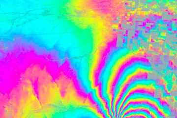 Interferograms released by NASA reveal how much the earth was deformed by the magnitude-7.2 earthquake that struck Baja California and the U.S. Southwest on April 4, 2010. The data, collected by the JPL-developed Uninhabited Aerial Vehicle Synthetic Aperture Radar (UAVSAR), “reveal that in the area studied, the quake moved the Calexico, Calif., region in a downward and southerly direction up to 80 centimeters (31 inches).” UAVSAR flies the San Andreas fault every six months; the interferogram is generated from differences in measurements between the flights.

Comments
blog comments powered by Disqus