Early Irish Maps
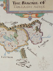 Britain’s National Archives has launched a collection of early modern maps of Ireland; the more than 60 maps date from the late 16th to early 17th century, a period during which England was colonizing Ireland. “Attractive and colourful, these maps include the famous 1567 map of Hibernia by John Goghe, and are normally held in our safe room. But now, as a result of our digitisation programme, these valuable treasures are accessible to millions globally,” writes the Archives’ Rose Mitchell. Accessible, but not free: it’ll cost you a few quid to download a PDF.

Comments
blog comments powered by Disqus