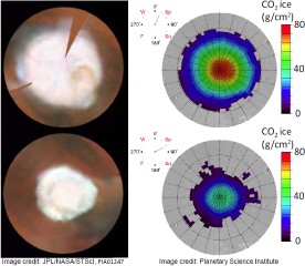
Mapping the Martian Polar Caps
 Astronomy reports that the Planetary Science Institute has released “the first detailed maps that show the amount of dry ice (solid carbon dioxide) deposited in the polar regions of Mars. The maps reveal how the ice thickness varies with the seasons.” The maps were created from spectroscopy data taken by the Mars Odyssey spacecraft over two Martian years. (Image credit: Hubble Space Telescope images by JPL/NASA/STScI; maps by Thomas Prettyman of the Planetary Science Institute.)

Comments
blog comments powered by Disqus