GOES 14 Full-Disk Thermal Infrared Image Shows Hurricane Bill
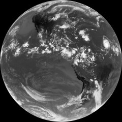 The first full-disk thermal infrared image of the Earth from the GOES 14 geostationary satellite, taken on August 17, shows Hurricane Bill forming in the Atlantic. In this image, the hotter a surface, the darker it appears; from the NASA Earth Observatory writeup:
In the heat of the midday sun, the exposed rock in sparsely vegetated mountain ranges and high-altitude deserts in western North and South America are dark. In North America, the temperatures cool (fade to lighter gray) along a gradient from west to east, as the semi-deserts of the West and Southwest transition to the grasslands and croplands of the Great Plains, which transition to forests in the East.
It’s even more stunning at full resolution.

Comments
blog comments powered by Disqus