‘Accidental’ Maps from Geotagged Photos
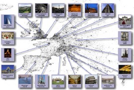 New Scientist: “David Crandall and colleagues at Cornell University in Ithaca, New York, analysed the data attached to 35 million photographs uploaded to the Flickr website to create accurate global and city maps and identify popular snapping sites.” Here’s a gallery; to reiterate, the maps are generated purely from the positions of geotagged photos. Here’s the research paper (PDF). Via MetaFilter and YahooGeo.

Comments
blog comments powered by Disqus