Titan in Stereo
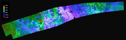
Topographic maps of Saturn’s largest moon, Titan, have been created from stereo pairs of radar images obtained by the Cassini probe. “The new flyover maps show, for the first time, the 3-D topography and height of the 1,200-meter (4,000-foot) mountain tops, the north polar lake country, the vast dunes more than 100 meters (300 feet) high that crisscross the moon, and the thick flows that may have oozed from possible ice volcanoes.” In 19 flybys of Titan, Cassini has mapped two percent of the surface in stereo. Images and flyover movies are available here, here and here. Via CassiniSaturn.
Previously: Topography of Titan; “Extraterrestrial Islands in a Methane Sea”; Mapping the Solar System: Mercury and Titan; Huygens Probe Images of Titan.

Comments
blog comments powered by Disqus