North Carolina Maps
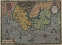 North Carolina Maps digitizes old maps of North Carolina; in beta (who are they, Google?) for the moment, but plans call for more than 1,500 maps, ranging from the 1590s to the 1960s. It’s a collaboration between the North Carolina State Archives, the North Carolina Collection at UNC Chapel Hill, and the Outer Banks History Center. According to the announcement, about 750 maps are available so far; the Outer Banks Center’s maps are coming in the fall. Via MapHist (thanks again, Tony).

Comments
blog comments powered by Disqus