Topography of Titan
The Planetary Society Blog reports:
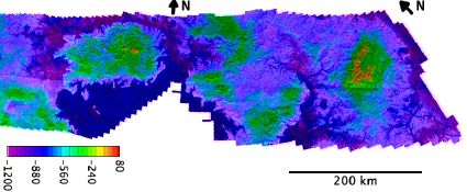
On Monday, with no fanfare, JPL posted the first detailed topographic map of part of Titan. I suppose the map doesn’t strictly qualify as a pretty picture, but it is a tremendously important data set. …
The RADAR team produced this map by comparing two views of a strip of land near Titan’s north pole. During the two flybys, which took place on February 22 and April 11, 2007 (known as the T25 and T28 Titan flybys), the RADAR instrument looked at the same area from slightly different directions. By using parallax — how points shift relative to each other as seen from the two different viewpoints — the wizards at the United States Geologic Survey in Flagstaff, Arizona computed the color-coded topographic map. In a map spanning 1,700 kilometers across the surace of Titan (that’s about 10 percent of the moon’s circumference), there is only about 1,300 meters of vertical relief. This is a very, very flat area.
Image credit: NASA/JPL/USGS. Overlay by Emily Lakdawalla.
Previously: “Extraterrestrial Islands in a Methane Sea”; Mapping the Solar System: Mercury and Titan; Huygens Probe Images of Titan.

Comments
blog comments powered by Disqus