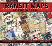
Review: Transit Maps of the World
Transit Maps of the World
by Mark Ovenden
Penguin, 2007. Paperback, 144 pp. ISBN-13 978-0-14-311265-5
 Billed on its cover as “the world’s first collection of every urban train map on Earth,” this is, in fact, the second revised edition of this book, which first came out in 2003 as Metro Maps of the World. (Maybe that was the first collection.) Even so, Transit Maps of the World does live up to its billing in that it provides reproductions of every urban subway system map — I didn’t count them — on the planet. It would have been valuable enough if it had simply collected all the system maps, one to a page, but author Mark Ovenden is more ambitious than that.
Transit Maps of the World is interested in transit system maps from a design perspective: the focus is not on the development of transit systems, but on the evolution of their maps. The book is organized accordingly, split into six zones with decreasing levels of detail: Zone 1 covers those systems with long histories and several revisions in map style, with each city getting between two to four pages; Zone 6 collect those relatively new systems that have had no more than one system map, and these maps are reproduced as tiny images. Given the focus on map design, it may also come as no surprise to learn that Ovenden’s interest is in the change from topographical, geographically accurate map designs to angular, Beck-style diagrams: the text approves of such changes when they occur, and disapproves when they fail to do so or change back.
Those interested in transit systems for their own sake, or who have an interest in more recent systems, may well be disappointed by the focus on map design or the short shrift given to some systems, as will people looking for maps of other aspects of urban transit, such as suburban commuter rail networks bus systems, which are outside this book’s terms of reference. But, as usual, I’m quibbling. Map design is a fascinating subject, and the mere fact of being able to compare so many designs from so many cities is instructive. And, even through Ovenden’s design lens, this book offers a window on virtually every major city in the world through its urban train system; as travellers, these systems are frequently our first real encounter with these cities, so it’s a fitting starting point.
Previously: Transit Maps of the World; Transit Maps of the World (Again).
- Buy Transit Maps of the World at Amazon.com

Comments
blog comments powered by Disqus