The Gough Map Book Published
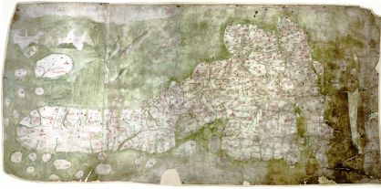
The 14th-century Gough Map, the oldest surviving map of Great Britain, is getting renewed attention with the publication of Nick Millea’s study, which, Tony Campbell says, “is the first study for fifty years of this highly important map.” To demonstrate the Gough Map’s accuracy, the book georectifies the map and superimposes upon it a modern map of Britain. Its relative accuracy is what makes the map interesting, according to the Daily Mail article (via Boing Boing):
“There are 600-odd places and, if you compare it with a modern map, most of them are in pretty much the right spot,” says Millea.
“We don’t know whether they did the coastline first then filled in the interior, or whether it was done by word of mouth — a verbal map — so they put in London then worked outwards, adding places they knew.”
Nick Crane, topographer and presenter of TV series Map Man, thinks they may have used an astrolabe — a highly technical instrument used by classical astronomers, navigators and astrologers which involved checking the horizon, the stars, the sun and all sorts of angles.
“This could be the beginning of mathematical map-making — some of the points of latitude have probably been measured through astronomy,” he says.
The Telegraph article, which is briefer, also looks at how the age of the undated map has been estimated (via MapHist).
See also ABC News Australia.
Previously: The Gough Map.
- Buy The Gough Map at Amazon.com

Comments
blog comments powered by Disqus