London Pedestrian Map
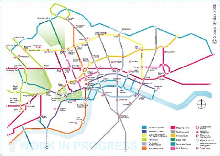
The London Pedestrian Routemap is a work in progress the aim of which “is to encourage walking in London. It does this by providing a simple, memorable picture of key walking routes in the Capital. At present there is no such map. The Routemap shows how key places connect by straightforward routes of varying character.”
According to the project page, the routes are based on research rather than arbitrary, but Hana Loftus has some objections to the routes chosen:
These routes are indeed the most direct, and currently most people do walk along main roads, but that doesn’t always make these the best routes. For a start, they aren’t quicker, because they are so crowded, and if you are elderly, disabled, or with a pushchair, they are virtually unnavigable. You would be better to duck up and along Wigmore Street than go along Oxford St, for example. Secondly, the air pollution of all those cars isn’t great, either. Thirdly, by only highlighting what are essentially the very simplest routes around town, the map isn’t showing what you really want to know on foot — how to go diagonally from, say, Kings Cross to the British Museum. Sticking to the main roads is not the most time-efficient route for this.
Via Things Magazine.

Comments
blog comments powered by Disqus