Israel and the Holy Land, Past and Present
 I’m overdue in presenting a couple of links regarding maps of Israel and/or the “Holy Land,” which terms may or may not be interchangeable, but you get the general idea as to area.
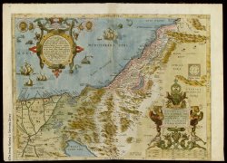
Holy Land Maps is an online collection of more than 1,000 maps, dating back as far as the 15th century, from the Eran Laor Cartographic Collection of the Jewish National and University Library. Uses MrSid format, but static images are also available. The site is in English and Hebrew. Via MapHist.
For a modern view, on the other hand, see Eye on Israel’s Flash-based map (thanks, peacay).

Comments
blog comments powered by Disqus