Map Snapper
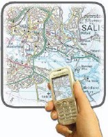 The Map Snapper project seems an awfully complicated way to generate local information and mobile maps, particularly since most of this stuff is available over wireless networks anyway. Essentially: take a photo of a map with a cameraphone, send photo to central servers, which process the map, identify it, and send it back with symbols added indicating points of interest. The point is, you can already access the online map services (including local search) via mobile devices, and GPS is being added to phones already, so this seems to be a roundabout way of producing what’s already available. Reinventing the wheel, as it were. Why bother? Via Engadget.

Comments
blog comments powered by Disqus