Wikimedia London Underground Maps
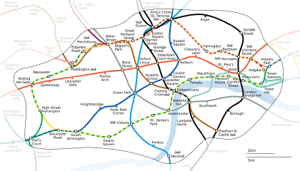
In response to Transport for London’s crackdown on London tube map remixes (previous entry), the Wikimedia Commons is putting together a series of freely available maps of the London Underground. The maps are generated using PHP to process GPS data; the maps are available in SVG and PNG formats. (Enough acronyms?) Zone maps, individual line maps, and maps of the bombings are available. One caveat: because they’re processed from GPS tracings — automated processes do not make for original graphic design — they’re all to scale rather than diagrams à la Beck, which may or may not be a good thing, depending. Via Boing Boing.

Comments
blog comments powered by Disqus