New Map of Jasper National Park
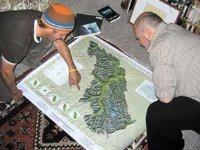 The Jasper Booster reports that two Jasper residents named Mike (Mike Mitchell and Mike Day) have spent the past few years designing a new map of Jasper National Park, the first map of the entire park since Parks Canada released one on its 100th anniversary in 1985. (I have that map: it’s essentially a 1:250,000-scale topo map.) This project — a partnership with the Friends of Jasper National Park — is a bit more ambitious, though, with artistic pretensions and trail locations verified by GPS (trails are frequently marked incorrectly on Canadian topo maps). The map is scheduled for release next year, to mark the park’s centennial. Via Maps-L.

Comments
blog comments powered by Disqus