The Paleogeography of North America
 Via Cartography, a stunning collection of maps depicting the paleogeography of North America.
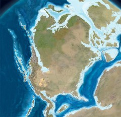
The images presented here show the paleogeography of North America over the last 550 million years of geologic history. The 40 images shown here are selected from a suite of approximately 100 maps that are in time slices mostly 5-10 million years apart. By using such tightly spaced time slices, individual paleogeographic and tectonic elements can be followed and intuitively related from time slice to adjacent time slice. Because of space limitations only 40 of the 100 images are presented here but but most shifts of tectonic elements and depositional systems can still be followed.
More from BLDGBLOG. Matt Perry has taken the images and compiled a 7.2-MB animated GIF, cycling through the ages, as it were.

Comments
blog comments powered by Disqus