SF Bay Area Geology
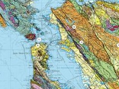 The USGS’s San Francisco Bay Region Geology and Geologic Hazards page has a lot going for it, mapwise. No surprise that much of it has to do with earthquake risks. There are three main sections: geologic maps compiled from several sources that show materials and structures; quaternary maps that show fault lines that have slipped during the Quaternary period (i.e., within the last 1.8 million years); and liquefaction maps that show where the ground is at risk of turning into quicksand during an earthquake. In each section, maps can be viewed through a Flash viewer or downloaded as either JPEGs, PDFs, or Google Earth files. Via MAPS-L.

Comments
blog comments powered by Disqus