The Gough Map
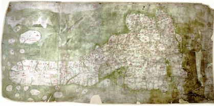
The Gough Map is the oldest surviving road map of Great Britain. (Pictured above; east is at the top of the map.) The map itself dates to around 1360, but was discovered by Richard Gough in 1774, and donated to Oxford’s Bodleian Library in 1809, where it remains today. Now, a joint project between the Bodleian and Queen’s University, Belfast, is under way to create an online interactive version of the Gough Map. That online version is available here; it’s an ArcIMS-based viewer with layers. Via MapHist.
Related reading: The King’s Two Maps: Cartography and Culture in Thirteenth-Century England by Daniel Birkholz.

Comments
blog comments powered by Disqus